Universal Fit Product.
010-C0713-00
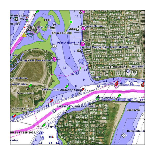
BlueChart g2 Vision HD - VUS012R - Tampa - New Orleans - microSD™/SD™Coverage:Bradenton, FL through New Orleans, LA including Apalachicola, Mobile, the Mississippi Delta, Chandeleur Islands, and a portion of Timbalier Bay. Also covers Lake PonchartrainPremium Mapping and Graphics CapabilitiesDetailed nautical charts, in vector object oriented format, derived from government charts and private sources to provide port plans, depth contours, navigational aids, and tides and currents in a seamless chart presentationShaded depth contours and intertidal zones with spot soundingsAerial photos of ports, marinas, bridges and navigational landmarks and realistic "view from space" high-resolution satellite imageryUp to 1-foot HD contours provide a more accurate depiction of bottom structure for improved fishing charts and navigation in swamps, canals, marinas and port plansGarmin Auto Guidance 3.0 technology is now capable of providing routing guidance¹ to virtually any accessible destination on the waterWorldwide coverage available in regionalized cutsBased on the standard BlueChart g2 HD features, BlueChart g2 Vision HD provides premium mapping and graphics capabilities. Plug a BlueChart g2 Vision HD card into your compatible chartplotter's microSD™/SD™ card slot to tremendously expand its mapping capabilities. BlueChart g2 Vision HD is our premium marine cartography for use with Garmin chartplotters. It includes all the features of BlueChart g2 HD charts and adds Garmin exclusive Auto Guidance 3.0. Garmin Auto Guidance 3.0 technology quickly searches relevant charts to suggest a course according to your boat's dimensions and creates a visual path that seeks to avoid low bridges, shallow water and other charted obstructions. With version 3.0, Auto Guidance can guide the user and in and out of more places more effectively, including entering and exiting marinas.¹BlueChart g2 Vision HD features seamless chart presentation with 1-foot HD contours that pr


)
)