Unit 1, 41 Performance Drive. Richmond hill ON
Skip to Main Content
Garmin Bluechart 174 Marine Cartography 010-C0722-00
609980_1_.jpg?width=100&quality=0.555345_1_.jpg?width=100&quality=0.5

Garmin Bluechart 174 Marine Cartography 010-C0722-00

0.00stars out of 5 ( 0 )
FREE SHIPPING
IN CANADA
90 DAYS RETURN
GUARANTEE
CANADIAN OWNED
IN ONTARIO
STARTING FROM
CAD$ 474.78
On Sale For
  SEE PRODUCT OPTIONS   ADD TO CART
Omnia icon

Omnia Product Expert is nline !

FOUND A LOWER PRICE? We'll Beat Any Lower Price You Find!

Some Condition Applies*

  Garmin Bluechart 174 Marine Cartography 010-C0722-00 SKU Listing / Specs

Purchase Part Number Image View Name Detail Specs UPC
SKU: 010-C0722-00
CAD$ 474.78

 Enlarged View

Garmin Bluechart 174 Marine Cartography 010-C0722-00
 SPECIAL ORDER
SPECIAL ORDER (Estimated Ship Date: 4 - 8 Weeks)
UpdatedOn: 10/3/2025 12:00:00 AM
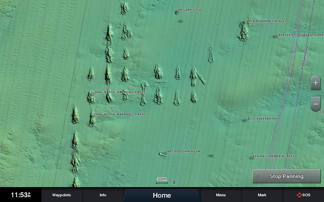
  Universal Fit Product.

753759069025

 Hot Product recommendation:

  • High-resolution satellite imagery enhances chart depictions for superior situational awareness so you can navigate with a clear moving-map representation of your boat's position.
  • Bluechart g2 vision is preprogrammed on sd data cards for use in newer Garmin equipment
  • Realistic navigation features show everything from shaded depth contours and coastlines to spot soundings, and more
  • Fishing charts focus on bathymetric contours with less clutter on the display
  • Choice of 3-d marinereye view or fisheye view makes chart reading and orientation easier
AMAZON.CA PRODUCT DESCRIPTION BlueChart g2 Vision HD on SD Card VUS021R California-Mexico, MFG# 010-C0722-00, Pt. Arena to Puerto Vallarta, including Mendocino, San Francisco Bay, Channel Islands, San Diego, & Baja Peninsula. General coverage for the Mexican coast. FROM THE MANUFACTURER The Garmin BlueChart g2 Vision SD Card, California / Mexico offers the same rich detailed charting of BlueChart g2 to help you get the most out of your Garmin chartplotter. In addition, g2 Vision features a growing database of high-resolution satellite imagery, above and below the water 3D perspectives, auto guidance technology, aerial photographs for real world references and coastal roads with points of interest. The g2 Vision features high-resolution satellite imagery that, when overlaid on the chart, provides you with unparalleled situational awareness, and auto guidance technology that searches chart data to suggest the best passage to your destination. This unit also comes with aerial reference photography which provides real-world photos of ports, harbors, marinas, waterways, navigation landmarks and other points of interest, offering you another powerful tool for navigating unfamiliar waters. Garmin's BlueChart g2 sets a new standard in marine cartography with its MarinerÂ?s Eye View perspective providing a birdÂ?s eye view from behind the boat showing chart information for a quick, reliable and easy position fix, as well as Fish Eye View 3D perspective which provides an underwater view that visually represents the sea floor according to the chart's information. The g2 has fishing charts that allow you to hide navigation data from the SD card while leaving the bottom contours and depth soundings for your next fishing adventure, and includes tides, currents, marine services, coastal roads and points of interest. The BlueChart g2 SD Card, California / Mexico provides coverage of the west coast of California and Mexico from Mendocino down to Salina Cruz, including: San Francisco Bay, Channel Islands, San Diego, the whole Baja Peninsula, Mazatlan, and Acapulco. This product is compatible with most of Garmin's new fixed-mount chartplotters, although user's should check the manufacturer's website to see a product compatibility table for the list of products that Garmin recommends with this software.What's in the BoxGarmin BlueChart g2 Vision SD card with maps of California through Mexico, and instruction pamphlet.

 TRUSTED CANADIAN REVIEWS:

  Share A Review!  | Total Rating: 0
Loading...