Universal Fit Product.
{htmlentities({htmlentities(Country:Netherlands)})}
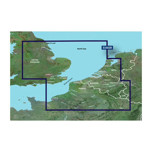
BlueChart g2 HD - HXEU002R - Dover to Amsterdam & England Southeast - microSD™/SD™Coverage:British coast: from Scarborough Harbour to Newhaven, including River Thames to London. Continental coast: from Amsterdam to FecampImprove your view with 1-foot HD contoursDetailed nautical charts derived from government charts and private sources to provide port plans, depth contours, navigational aids, and tides and currents in a seamless chart presentationVector object oriented dataShaded depth contours and intertidal zones with spot soundingsWorldwide coverage available in regionalized cuts1-foot HD contours provide a more accurate depiction of bottom structure for improved fishing charts and navigation in swamps, canals and port plansSee your vessel's precise position on-chart in relation to navaids, spot soundings, coastal features, anchorages, port plans, waterways, obstructions, restricted areas and more. BlueChart g2 HD provides seamless chart presentation with 1-foot HD contours to provide a more accurate depiction of bottom structure for improved fishing charts and navigation in swamps, canals, marinas and port plans. Coverage is available worldwide in regional offerings for Garmin handhelds and Your ViewBlueChart g2 HD marine maps feature crisp labeling and an exceptionally smooth presentation on your chartplotter addition to the basic charts, tidal stations, currents, depth contours, IALA symbols and included full bathymetric fishing charts with detailed contours, BlueChart g2 HD also offers smooth transitioning between zoom levels and seamless continuity across chart Your ScreensBlueChart g2 HD also adds Shallow Water Shading to allow the user to enable contour shading for all depth contours shallower than the user-defined safe fishing charts are designed to emphasize bathymetric contours with less visual clutter on the 's also a choice of standard 2-D direct overhead or 3-D "over-the-bow" map views for easier chart reading and g2 HD charts als